What is God's Eye View?
God's Eye View is an open-source 3D OSINT globe that puts public aircraft, maritime, orbital and environmental information into a shared geographic view. OSINT means open-source intelligence: here, the inputs are public feeds and documented provider APIs. The useful starting point is a local browser application where a developer can inspect the source, identify the provenance of a layer and follow an individual object through the scene.
Read the full overview
The globe uses Cesium with JavaScript modules and a Vite development server. The default setup can start without API keys, using Esri imagery with an OpenStreetMap fallback and keyless terrain. Additional providers unlock photorealistic 3D tiles, vessel data, street imagery or voice. The software runs on your machine, while selected feeds, map tiles and optional AI requests still contact external services.
Tracking and visualization need to be interpreted separately. Aircraft feeds contain reported telemetry; satellite positions are calculated from orbital elements. Road traffic is a simulation, with optional live aggregate flow speeds. CCTV coverage volumes and launch trajectories are estimates. Thermal, night-vision and detection effects change how the scene looks; they do not turn public imagery into a physical thermal sensor or verified object detector.
The repository began in June 2026. The latest non-prerelease reference checked was v0.2.1, while this profile also reviews the current main branch at its recorded commit. A feature documented on main may require a newer checkout than that release. Start with the official installation guide and keep the revision and provider configuration together when reproducing a scene.
 God's Eye ViewAnalytics & BI
Local 3D OSINT globe for public flight, satellite and geospatial data
Key capabilities
- Layered 3D exploration Switch between a global view and local detail while combining map imagery, aircraft, satellites, earthquakes, public cameras and infrastructure. Each layer has its own source, refresh behavior and attribution requirements; availability varies with location and provider.
- Tracked contacts and camera views Select a reported aircraft or vessel, inspect the available metadata, follow its trail and keep the camera attached. Cockpit-style views and nearby-contact lists provide a different way to inspect a feed; they do not add telemetry that the source has not supplied.
- Environmental context Inspect weather, fire and seismic information alongside other layers. Some data is observed, some is forecast and some is a bundled fallback. Keep the timestamp and source visible when using a scene in a briefing or published explanation.
- Voice and agent tools Optional voice control can navigate the scene, query selected entities and draw annotations. It needs a configured AI provider. The project also includes an MCP server for clients that support tools, links and, where supported, an embedded globe panel.
- Annotations and share links Draw pins, lines and boundaries, then share view state such as camera position, active layers and a tracked target. A shared link reconstructs a live view; it does not freeze the underlying provider data at the moment the link was created.
- Scene authoring The Director workflow supports authored camera moves and scene bundles for demonstrations or explanatory clips. Review imported data packs and remote asset URLs before sharing a bundle, particularly when its contents include provider imagery or personally identifying public data.
- Modular application construction The application export separates scene, controls, data and tools behind explicit constructors and lifecycle cleanup. Developers can supply geospatial adapters without treating the standalone UI as a drop-in, multi-viewer widget; the application documentation describes those ownership boundaries.
- Local setup and optional providers Use Node.js 24.14.0 or later within the supported 24.x line, or supported 26.x, then run npm ci, npm run doctor and npm run dev. Pinokio is another documented launch path. Keys upgrade selected capabilities rather than being a prerequisite for the initial globe.
Where God's Eye View fits
Geospatial prototypes and data exploration
Use the globe to see whether several public sources answer a geographic question together before building a dedicated application. Inspect one known aircraft, one satellite and one event with source timestamps available. Missing coverage, delayed messages and a failed upstream request should be visible in your interpretation, even when the 3D scene remains visually convincing.
Public-data explainers and demonstrations
Build a camera tour that explains a route, an orbit, a weather pattern or infrastructure around a location. Keep observed data separate from simulated traffic and estimated camera geometry. For a published video, preserve provider credits and describe when the information was captured; a current-looking animation can contain older fallback data.
Agent-connected mapping experiments
The MCP setup guide connects a local running app to an agent client over STDIO. Browser-panel support depends on the client, and the panel build is a separate step. Test one location request, one entity query and a failed-provider case before incorporating the tools into an automated workflow.
Custom layers and geospatial services
The application construction API accepts explicit scene, controls, data and tool constructors. Forward search can use local coordinate parsing and bundled names before reaching configured geocoders. Integrators should own cancellation, cleanup, attribution and credential transport; the standalone app still allows only one instance per page.
Reproducible scene review
Record the checkout commit, enabled layers, optional keys, provider terms and capture time alongside a shared scene. URL state and a scene file reproduce the presentation more reliably than a verbal description, but changing live feeds can still produce a different result. Retain a static source-linked capture when exact historical evidence matters.
Positioning and limitations
God's Eye View is a public-data visualization application for developers, geospatial enthusiasts and technical communicators. Its strength is bringing several independently sourced signals into one inspectable scene. It does not establish the completeness, accuracy or operational suitability of any individual feed, and the project should not be presented as a replacement for certified aviation, navigation or emergency systems.
Choose it when the task benefits from a navigable globe, source-level customization and a local agent interface. A conventional GIS workflow is a better fit for reproducible spatial analysis, coordinate-system management or a controlled geospatial data pipeline. For infrastructure metrics and SQL dashboards, Grafana and Apache Superset address different workloads.
The LICENSE file grants MIT terms for the source code, with separate terms for third-party datasets and models. GitHub currently labels the combined file NOASSERTION; that automated label does not erase the MIT text. Some bundled cable and event-imagery datasets are non-commercial, while OpenStreetMap-derived data has its own attribution and share-alike conditions. Review the particular assets you use rather than assuming one license covers the whole scene.
The software has no code purchase price. Local hardware, hosting and optional services can still cost money. Google Maps tiles, place search and voice providers can be metered; free provider plans have eligibility rules and quotas. The source and attribution ledger is the useful reference before enabling a feed or republishing its output.
View interface preview
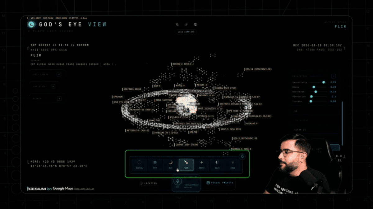
The practical value is the ability to inspect how a geographic presentation is assembled. A developer can trace an entity to a provider adapter, replace a source and compare the rendered result with the original payload. That makes the project useful for learning Cesium and testing an interface around public data without first designing every layer from scratch.
Local execution is a deployment boundary, not a promise that every request stays offline. Provider keys and the chosen layers determine which services receive requests. The default server is intended for loopback use. Read the security and LAN-sharing notes, restrict browser-side provider keys and keep server secrets out of the client bundle before changing that exposure.
Start with the keyless path and prove one source end to end. Check freshness, unavailable feeds and fallback behavior before paying for higher-detail imagery or voice. Keep API budgets and rate limits explicit. A visually smooth camera tour should not hide that the underlying contact disappeared, its data aged or a provider returned an error.
A useful acceptance test is a known location, a known tracked object, one annotation, one share-link restoration and one interrupted network request. For MCP, also test shutdown and restart of the local app. The observations in this profile come from the pinned repository and its documentation; they are not an independent performance benchmark or a security certification.
“Local 3D OSINT globe for public flight, satellite and geospatial data”
Technical details
- Access
- Self-hosted
- Source model
- Open source
- License
- MIT (source code)
- Founded
- 2026
- Data location
- Local application; live maps, feeds and optional voice use selected external providers and their regions
- Pricing model
- Open source
- Pricing details
- Software and service terms ↗
- API
- Available
- API documentation
- Read API documentation ↗
- Version reference
- v0.2.1; main @ ad328b9 ↗
- Source checked
- October 15, 2026
- Website
- github.com ↗
- GitHub
- Source repository ↗
What to verify
Profile audiences: Developers, IT Teams.
- Confirm current features, licensing and support terms.
- Validate deployment, data location and access control.
- Test integrations, exports and recovery workflows.
Reviews of God's Eye View
No published reviews yet.
Loading review form…